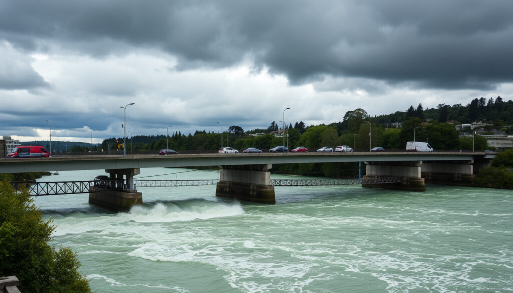
Kennedy Good Bridge Lower Hutt: History, Traffic & Floods
Lower Hutt has built its road network directly across one of New Zealand’s most flood-prone rivers — a choice that repeatedly tests the city’s infrastructure and the communities on either side. Kennedy Good Bridge sits at a key crossing point, linking communities while sitting in the path of Te Awa Kairangi, the Hutt River. With a major river protection programme now reshaping the area around it, here’s what residents, commuters, and anyone curious about regional infrastructure need to know.
Location: Lower Hutt, New Zealand · Crosses: Te Awa Kairangi / Hutt River · Named after: Mayor Kennedy Good · Maori river name: Te Awa Kairangi
Quick snapshot
- Two-lane road bridge opened in 1979 (Wikipedia – Hutt River)
- First bridge at its site (Wikipedia – Hutt River)
- Named after the Mayor of Lower Hutt at the time of its opening (Wikipedia – Hutt River)
- Exact construction date and contractor details
- Current daily traffic volume figures
- Structural inspection history
- April 2026: Night-time southbound closures on SH2 for safety barrier installation
- 2026–2029: Ongoing road works as part of flood protection programme
- Planned gravel extraction downstream to lower river bed levels
- Queens Drive closure until approximately 2029
Key attributes of Kennedy Good Bridge and the surrounding river system are summarised in the table below.
| Attribute | Details |
|---|---|
| Type | Road bridge |
| Location | Lower Hutt, New Zealand |
| River crossed | Te Awa Kairangi / Hutt River |
| Named for | Mayor Kennedy Good |
| Key events | Flood closures, official opening 1979 |
| River length | 56 km |
| Catchment area | 655 sq km |
| Flood protection coverage | 200,000 residents |
What is the Maori name for the Hutt River?
The river that Kennedy Good Bridge crosses is officially known by two names: Te Awa Kairangi in Maori and Hutt River in English. The Maori name was formally recognised and appears in the Greater Wellington Regional Council records. The dual naming reflects the increasing recognition of Maori heritage in New Zealand’s official geographic nomenclature.
Te Awa Kairangi meaning
Te Awa Kairangi translates to “the river of sparkling waters” — a name that evokes the qualities Maori ancestors valued in the waterway. This name was not a colonial invention but connects to traditional Maori associations with the river long before European settlement. The name also appears in the broader programme now protecting the area: Te Wai Takamori o Te Awa Kairangi means “the soothing waters of the Hutt River” and was formerly known as RiverLink.
Official naming sources
The name Te Awa Kairangi appears in the New Zealand Geographic Names Database (NZGB) Gazetteer, which records official place names. Greater Wellington Regional Council uses both names interchangeably in its public communications, acknowledging the river’s dual identity.
Te Awa Kairangi carries a meaning that reflects how Maori communities understood the river — not just as a geographic feature but as a living resource. The formal recognition of this name in regional planning documents signals a shift toward incorporating indigenous knowledge into flood management strategy.
Who named Te Awa Kairangi?
The name Te Awa Kairangi is rooted in traditional Maori usage, linked to the original iwi who lived along the river. While specific attribution to a single individual is unclear, the name has been preserved through oral tradition and later documented as part of official naming processes. The Greater Wellington Regional Council notes that the Maori name reflects the river’s significance to tangata whenua.
Traditional Maori origins
Before European settlement, Maori transported produce grown in the Hutt Valley down the river by canoe and across the harbour to Wellington city. In the early nineteenth century, the Hutt River was deeper than it is now and navigable for some distance by large canoes and boats. This waterway was a commercial artery for Maori communities long before the first settlers arrived.
Official recognition
The name gained formal standing through the New Zealand Geographic Board’s gazettal process, which now maintains the official register of place names. This official recognition ensures that both the English and Maori names carry equal legal weight in regional planning and emergency management documents.
What does Te Awa Kairangi mean?
Te Awa Kairangi literally means “river of sparkling waters” — a poetic description that suggests clear, luminous water. The name carries cultural significance beyond its literal translation, representing the river’s importance to local iwi and the wider region.
Literal translation
Breaking down the name: “Te Awa” means “the river” and “Kairangi” relates to sparkle, gleam, or precious qualities. Together, the phrase describes water that was considered valuable and pure by those who named it.
Cultural significance
The name reflects the Maori concept of landscape as something that carries identity and meaning rather than simply existing as geographic fact. Wikipedia records on the Hutt River note that early European settlers observed that Maori had deep connections to the waterway, using it for transport and trade long before colonisation altered the valley’s character.
Kennedy Good Bridge Lower Hutt history
Kennedy Good Bridge opened in 1979 as a two-lane road bridge — the first bridge at its site — and was named after the Mayor of Lower Hutt at the time of its opening. The bridge replaced no prior crossing at this exact location, making it a new infrastructure addition to the Lower Hutt road network.
Official opening
The bridge opened during a period when Lower Hutt was experiencing significant population growth and urban expansion. As part of the city’s infrastructure development, the bridge provided a direct crossing over Te Awa Kairangi, connecting communities on either side of the river. The naming honoured the mayor whose administration oversaw its construction.
Named after mayor
Kennedy Good served as Mayor of Lower Hutt and the bridge bears his name as a tribute to his civic leadership. This tradition of naming significant infrastructure after serving mayors is common in New Zealand cities, reflecting community recognition of public service.
Kennedy Good Bridge Lower Hutt traffic and closures
Kennedy Good Bridge functions as a key link in Lower Hutt’s road network, carrying traffic across the Hutt River at a point where flooding can force sudden closures. The bridge sits within the Te Wai Takamori o Te Awa Kairangi flood protection programme area, which is undertaking major works between 2026 and 2029 that affect traffic patterns around the crossing.
Regular closures mean commuters should build extra travel time into their plans. Road users crossing Kennedy Good Bridge should check for updates before peak travel times, especially during the ongoing construction period through 2029.
Flood-related closures
The Hutt River has a documented history of flooding, with major floods recorded in 1855, 1858, 1878, two in 1893, two in 1898, and the last major flood in 1939. Greater Wellington Regional Council’s flood history documentation shows that over the last 155 years, 8 floods of at least 1 in 20 year magnitude were observed. The 1898 flood remains the largest in recorded history, with approximately 2,000 cubic metres per second discharge. The river’s catchment spans 655 square kilometres — nearly seven times the area of Wellington Harbour — and heavy rain at the top of the catchment takes only seven hours to become floodwaters at the river mouth.
Recent updates
Southbound closures on State Highway 2 from Kennedy Good Bridge to Melling Link occurred from Tuesday 7 April to Thursday 9 April 2026, between 9pm and 4am, to allow installation of new steel safety barriers north of Melling Link. Te Wai Takamori o Te Awa Kairangi’s April 2026 community update documented these closures. Longer-term, Queens Drive between Rutherford and High Street is closed until approximately 2029, and the roundabout at Queens Drive/High Street is being replaced with a traffic-signal-controlled intersection.
Kennedy Good Bridge Timeline
A chronological record of key events affecting Kennedy Good Bridge and the surrounding river corridor.
| Period | Event |
|---|---|
| Pre-European | Maori naming of Te Awa Kairangi |
| Early 19th century | River navigable by large canoes for trade |
| 1855 | Wellington Earthquake raised floodplain by 1.5 metres |
| 1858 | Largest European settler flood: 9 lives lost |
| 1898 | Largest recorded flood: ~2,000 cubic metres per second |
| 1979 | Kennedy Good Bridge opens as first crossing at site |
| April 2026 | Night-time safety barrier closures |
| 2026–2029 | Ongoing flood protection works affecting traffic |
Confirmed Facts vs What’s Unclear
Readers should note which details about Kennedy Good Bridge remain verified versus those still awaiting confirmation from authoritative sources.
Confirmed facts
- Bridge named after Mayor Kennedy Good
- Opened in 1979 as first bridge at site
- Crosses Te Awa Kairangi / Hutt River
- Part of Te Wai Takamori o Te Awa Kairangi flood programme
- Experienced flood-related closures
What’s unclear
- Exact construction start date and contractor
- Current daily vehicle traffic counts
- Formal structural inspection schedule and results
- Details of Kennedy Good’s mayoral tenure dates
The implication: travellers relying on Kennedy Good Bridge should treat any single route as provisional during flood season and construction phases through 2029.
What authorities say
The bridges are now back open. Motorists are advised to take care and allow extra time for journeys.
— Hutt City Council (announcement following flood closure reopening)
We are closing the bridges due to rising Hutt River levels. Please avoid the area and use alternative routes.
— NZ Police (public safety announcement during flood event)
This article draws primarily on Greater Wellington Regional Council, Te Wai Takamori o Te Awa Kairangi programme, and Wikipedia sources. Exact traffic volume data and the mayor’s specific tenure dates remain unverified across multiple sources. Readers seeking the most current closure information should check the NZ Transport Agency Waka Kotahi website and Hutt City Council social media channels directly.
Related reading: Nau Mai Haere Mai Māori welcome · Matariki stars meanings
gw.govt.nz, gw.govt.nz, teawakairangi.co.nz, teawakairangi.co.nz
Frequently asked questions
Where is Kennedy Good Bridge located?
Kennedy Good Bridge spans the Te Awa Kairangi / Hutt River in Lower Hutt, New Zealand, connecting communities on either side of the waterway within the Wellington region.
What is the Maori name for the Hutt River?
The official Maori name for the Hutt River is Te Awa Kairangi, which translates to “river of sparkling waters.” Both names are used in official regional council documents.
What does Te Awa Kairangi mean?
Te Awa Kairangi means “river of sparkling waters” — a name that reflects traditional Maori values about the quality and importance of the waterway to local communities.
Who was Kennedy Good?
Kennedy Good was the Mayor of Lower Hutt at the time the bridge opened in 1979. The bridge was named in his honour to recognise his civic contribution to the city’s infrastructure development.
Why was Kennedy Good Bridge closed recently?
The bridge experienced recent night-time closures in April 2026 as part of the Te Wai Takamori o Te Awa Kairangi programme. Safety barriers were installed north of Melling Link, requiring southbound closures on State Highway 2 between 9pm and 4am.
How long is the Te Awa Kairangi flood protection programme?
The programme is ongoing from 2026 through approximately 2029. Key works affecting Kennedy Good Bridge include road closures on Queens Drive, intersection modifications, and planned gravel extraction downstream of the bridge.
What is the flood protection standard for the Hutt River?
The current flood protection standard for Hutt Central is a 1 in 440 year return period, including allowance for climate change. Greater Wellington provides flood protection for 200,000 residents along Te Awa Kairangi.
How many people live in Lower Hutt?
Lower Hutt is part of the Wellington metropolitan area. The Hutt Valley region has a significant population that relies on bridges like Kennedy Good Bridge for daily commuting and commerce.
Greater Wellington and NZ Transport Agency are investing in flood defences that will shape Lower Hutt’s road network for decades. The implication is that residents who depend on Kennedy Good Bridge for daily travel will face continued disruption through at least 2029, but that disruption buys protection against flood events that historically severed the corridor for days at a time.
More related posts
 Tom Ford Oud Wood: Scent Notes, Price, Unisex Review
 Porsche 911 GT3 RS – Specs, Price & Availability in NZ
 Nga Manu Nature Reserve – Location, Animals & Visitor Guide
 iPhone 13 Mini to Buy: Best Refurbished Deals Ireland
 Michael Campbell Net Worth – 2024 Estimates and Career Highlights
 Bathurst Start Time NZ – 2025 Schedule TV Guide
 Blue Jays vs Yankees: Scores, Predictions, Odds 2026
 Auckland to Japan Flight Time: 11 Hours Direct to Tokyo